Iowa Crop Progress and Condition Report
May 22 – 28, 2023
DES MOINES, Iowa (May 30, 2023) — Iowa Secretary of Agriculture Mike Naig commented today on the Iowa Crop Progress and Condition Report released by the USDA National Agricultural Statistics Service. The report is released weekly April through November.
“Nearly all of Iowa’s corn and soybeans are now planted thanks to the seasonal temperatures and unseasonably dry conditions over the past week,” said Secretary Naig. “As the calendar flips to June, Iowans can expect scattered thunderstorms and the warmest stretch of the season thus far with weather outlooks indicating a gradual shift from drier conditions to better chances of rain.”
The weekly report is also available on the USDA’s website at nass.usda.gov.
Crop Report
Very dry conditions and relatively warm weather meant Iowa farmers had 6.6 days suitable for fieldwork during the week ending May 28, 2023, according to the USDA, National Agricultural Statistics Service. Farmers were still planting some corn and soybeans. However, farmers took advantage of the dry warm weather to cut a lot of hay. Other field activities included spraying pesticides on emerging crops.
Topsoil moisture condition rated 10 percent very short, 40 percent short, 49 percent adequate and 1 percent surplus. Subsoil moisture condition rated 10 percent very short, 36 percent short, 53 percent adequate and 1 percent surplus.
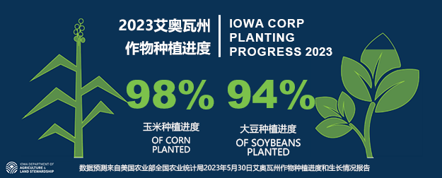
Planting is nearing completion, with 98 percent of Iowa’s corn crop planted, 8 days ahead of last year and 11 days ahead of the 5-year average. Eighty-five percent of the corn crop has emerged, 1 week ahead of last year and the average. Iowa’s first corn condition rating of the year was 0 percent very poor, 2 percent poor, 21 percent fair, 65 percent good, and 12 percent excellent. Ninety-four percent of Iowa’s expected soybean crop has been planted, just over a week ahead of last year and 15 days ahead of normal. Sixty-seven percent of soybeans have emerged, 8 days ahead of last year and the average. Iowa’s first soybean condition rating of the year was 1 percent very poor, 3 percent poor, 25 percent fair, 59 percent good, and 12 percent excellent. Ninety-seven percent of the expected oat crop has emerged, 6 days ahead of normal. Twenty-one percent of the oat crop has headed, 8 days ahead of last year and the average. Oat condition declined to 74 percent good to excellent.
Fifty-two percent of the State’s first cutting of alfalfa hay has been completed, jumping from close to the 5-year average pace to nearly 2 weeks ahead. Hay condition fell 8 percentage points to 58 percent good to excellent. Pasture condition dropped to 50 percent good to excellent. No major livestock concerns other than precipitation needed to improve pasture conditions.
Weather Summary
Provided by Justin Glisan, Ph.D., State Climatologist, Iowa Department of Agriculture and Land Stewardship
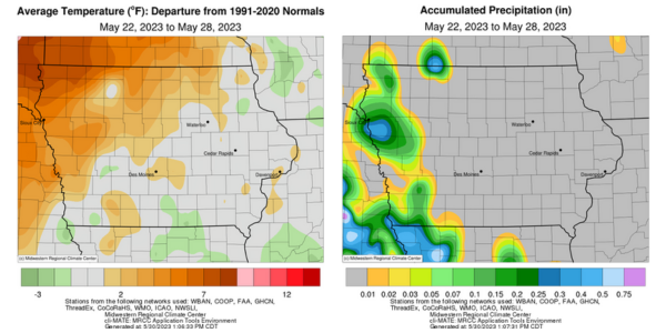
A nearly stationary high pressure center, known as a Rex Block, dominated the weather pattern across the region through the reporting period. This atmospheric configuration blocked the large-scale west-to-east flow, setting up a dry pattern for the region; most of Iowa’s stations observed rainfall deficits from 1.00 to 1.20 inches. Warmer to near-seasonal temperatures were reported northwest to southeast with the statewide average temperature at 65.1 degrees, 2.1 degrees above normal.
Daytime highs on Sunday (21st) were in the 70s statewide while a few northwestern stations reported low 80s with sunny skies and winds out of the south. Overnight conditions remained seasonal with lows in the 50s and patchy fog in western Iowa at sunrise on Monday (22nd). Skies became partly cloudy through the day as the remaining hints of Canadian wildfire smoke produced a copper tinge to higher level cumulus. Temperatures were again pleasant with mid to upper 70s reported under a light southerly wind. Cloud cover remained in southwestern Iowa into Tuesday (23rd) morning with calm to slightly breezy conditions and lows in the mid to upper 50s. Daytime highs pushed into the low to mid 80s with a few passing clouds in western Iowa. Winds became light and variable in eastern Iowa over the nighttime hours as the wind direction gradually shifted easterly through Wednesday (24th) morning. Afternoon conditions quickly warmed into the low to mid 80s with spotty upper 80s at several stations in eastern Iowa; the statewide average high was 83 degrees, nine degrees above normal. Rain showers with a few rumbles of thunder developed in southwestern Iowa just before sunset and slowly moved northwest. Additional, isolated cells redeveloped into late Thursday (25th) morning along a localized boundary as a weak cold front dropped north to south through the state.
Only 31 stations in western Iowa reported rainfall with six stations registering just a trace amount. Rain totals were generally under a tenth of an inch though higher totals ranged from 0.13 inch at a Community Collaborative Rain, Hail and Snow (CoCoRaHS) gauge in Atlantic (Cass County) to 0.40 and 0.42 inch-totals at two stations in Woodbury County. Afternoon skies were generally cloudless with a gustier easterly wind in eastern Iowa shifting to southeasterly farther northwest. Starry skies prevailed overnight into Friday (26th) with morning lows ranging from the mid 40s east to upper 50s west with a statewide average low at 46 degrees, seven degrees below normal; some western Iowa stations were anywhere from two to six degrees above average. Afternoon conditions continued to be warmer in the northwest, with highs in the low 80s while temperatures were up to 10 degrees cooler at stations in the east. Easterly winds persisted into Saturday (27th) as morning temperatures hovered in the upper 40s and low 50s. Ample sunlight and southeasterly winds pushed daytime highs into the upper 70s and low 80s, with a noticeable lack of humidity. With lower dewpoints and clear skies, temperatures dropped into the 50s on Sunday (28th) morning.
Weekly rain totals ranged from no accumulation at a majority of Iowa’s weather stations to 0.42 inch at Sioux City Airport (Woodbury County). The statewide weekly average precipitation was 0.02 inch, while the normal is 1.05 inches. Several stations reported the week’s high temperature of 88 degrees on the 24th, on average 13 degrees above normal. Fayette (Fayette County) and Vinton (Benton County) reported the week’s low temperature of 36 degrees on the 26th, on average 14 degrees below normal.

###
About the Iowa Department of Agriculture and Land Stewardship
Led by Secretary Mike Naig, the Department of Agriculture and Land Stewardship serves the rural and urban residents that call Iowa home. Through its 14 diverse bureaus, the Department ensures animal health, food safety and consumer protection. It also promotes conservation efforts to preserve our land and enhance water quality for the next generation. Learn more at iowaagriculture.gov.


 京公网安备 11010502031562号